O NÁS
ÚVOD
KONTAKTY
POVZBUZENÍ OD DĚDEČKA
LEDOVÉ ŠÍLENSTVÍ
UŽITEČNĚ STRÁVENÁ SOBOTA
SVÍTÍCÍ KRÁPNÍKY
OWENSKÁ ZÁHADA
OBŘÍ DŮL-GEOLOGICKÁ
EXPOZICE KOVÁRNA
TURISTICKÝ PROVOZ
ZÁKLADNÍ INFORMACE
BASIC INFORMATION
ZAHÁJENÍ PROJEKTU
ZMÁHÁNÍ ŠTOLY PROKOP
SKALNÍ ÚSEK ŠTOLY PROKOP
KONSTRUKCE V TÉTO ŠTOLE
UKONČENÍ PROJEKTU
FILMY
FOTOGRAFIE
ODBORNÉ ČLÁNKY
ALBEŘICKÁ JESKYNĚ
ZÁKLADNÍ INFORMACE
BASIC INFORMATION
FILMY
FOTOGRAFIE
PHOTOS
ODBORNÉ ČLÁNKY
ALBEŘICE
FOTOGRAFIE
CELNÍ JESKYNĚ
ZÁKLADNÍ INFORMACE
HISTORICKÉ FOTOGRAFIE
ODBORNÉ ČLÁNKY
JESKYNĚ TRUCOVNA
ZÁKLADNÍ INFORMACE
ODBORNÉ ČLÁNKY
KRAKONOŠOVA JESKYNĚ
ZÁKLADNÍ INFORMACE
FOTOGRAFIE
ODBORNÉ ČLÁNKY
MEDVĚDÍ JESKYNĚ
ZÁKLADNÍ INFORMACE
ODBORNÉ ČLÁNKY
HISTORICKÉ FOTOGRAFIE
SPELEOLOG 1. STUPNĚ
KONGRES 1989 BUDAPEŠŤ
SPELEOSETKÁNÍ 1982
SPELEOSETKÁNÍ 1986
1. VS ČSS 1990
JOSEFOVSKÁ STOKA II.
LOUČEŇ -STOKY
EXPEDICE KRN 85
SPELEOFÓRUM 85
PUBLIKAČNÍ ČINNOST
SEZNAM PUBLIKACÍ
ODBORNÉ ČLÁNKY
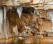
The Albeřická Cave lies in the head of the Albeřické údolí Valley in the Eastern Krkonoše Mountains in the abandoned pit Bischof Quarry 40 metres deep.The first report on the Albeřická Cave dates to 1885. Neverheless, professional exploration commenced not earlier than in the late 1970 sand continues till the present with some breaks. The Albeřická Cave is a complex cave system with domes, corridors, low passages, chimneys and shafts, complicated by numerous cave-ins. It is subdivided into several mutually interconnected altitude levels. Its total length is 725 metres and its altitude difference is 38.1 metres including permanently flooded tracts. The altitude range of the dry tracts oscillates around 20 metres depending on the water level height. The length of permanently dry tracts is 399 meters.
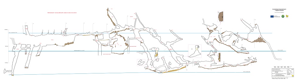
The Albeřická Cave can be subdivided into several different parts, more or less reflecting also the history of discoveries and exploration: the Chamber (Komora), the old part of the cave, the New Cave (Nová jeskyně) andthe permanently flooded spaces documented after pumpingin 2019.The biggest domes (with the exception of the artificialChamber) are located in the old part of the cave. Dome Iis about 96 m2 in area, Dome II is 75 m² in area, and Dome III is 30 m² in area.The permanently flooded tract includes domesapproximately 65 to 75 m² in area.The deepest and most voluminous shaftof irregular cross section is the Marble Abyss (Mramorová propast). The dry partof the shaft features a variable depth depending on the water level, reaching -13 metres, and the total depth of the shaft including its flooded part is -25 metres. Speleothem decorations are only found at two sitesin the old part of the cave, having the character of inactive flowstone. Minute dripstone formations of various colours are present in the New Cave.
Map of Albeřická cave:
The Albeřická Cave has formed in a body of crystalline limestones and calcitic dolomites 12-15 metres thick.The body strikes north-south, with foliation planes vertical or steeply dipping mostly to the east. On the western and eastern margins of the body, carbonate rocks host thin phyllite intercalations in progressively increasing numbers and finally pass into pure phyllites. The thickness of the body including this marginal zone reaches 40 metres.
Water level in the Albeřická Cave is oscillating but equal in all subterranean lakes. The highest recorded water level (+400 centimetres) was reaching -12 metres below the valley bottom at the cave level on 27 July 1997. The levels of water never reached high enough to be levelled with the valley bottom. The lowest natural water level, -547 centimetres below the long-term fixed marking of zero water level, was recorded on 16 February 2017. At that moment, the lowest measured water level in the cave was lying -21.5 metres below the valley bottom. During a pumping test in 2019, water level was lowered by 15.3 metres compared to that at the onset of pumping. The volume of 150.3 thousand m³ was pumped from the cave in total. A resurgence of karst waters lies near the former boarding house of Vinoř. Depending on the season of the year, 30-40 litres per second are issued on the flow of the Albeřický potok Stream in this area.
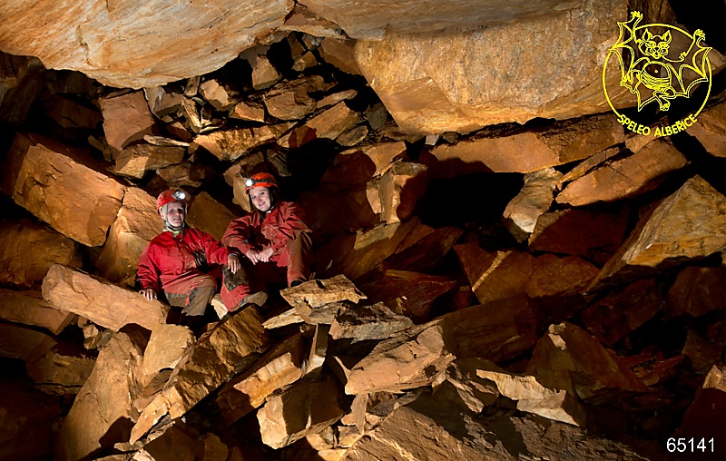
As concerns climatic conditions, the Albeřická Cave between its entrance and the Marble Abyss can be designated as a dynamic cave with classical summer and winter circulations in opposite directions. Winter months are associated with heavy glaciation in these spaces, with ice often persisting till the beginning of May. The rear tract of the cave as far as to the Marble Lakeis static, with temperatures ranging between 5.2 and 7.8 °C.Altogether 12 species of bats have been recorded in the Albeřická Cave, the most numerous being the greater mouse-eared bat and the lesser horseshoe bat. The cave was severely altered by quarrying in the latter half of the 19th century and the first half of the 20th century. At that time, a large portion of the cave system was probably removed.
Exploration of the the Albeřická Cave in recent years is conducted within the project Inventory and documentation of karst features in the Krkonoše Mountains run by the Krkonoše National Park Administration and co-financed from the European Union Operation Programme Environment (project No.CZ.05.4.27/0.0/0.0/15_009/0004533). The project covers four principal areas. First, it is necessary to make a field-based revision of the presence of karst features, especially caves, in the Krkonoše Mountains and review the results of previous investigations. Secondly, all these sites must be subjected to a very detailed documentation; new maps must be made in most cases.These practical tasks also include a pumping test in the subterranean lakes of the Albeřická Cave and test pitsin cave sediments. The third area is perhaps the most demanding one, being related to geology of selected caves and the study of their dripstone decorations and cave sediments. This research should explain why did the caves form at their specific locations and what geological structures controlled their genesis. The fourth area covered by the project involves a 3D model of the Albeřická Cave andpromotion of the results through articles and a book. The principal investigator of the whole 5-years' project is the Caving Club 5-02 Albeřice of the Czech Speleological Society. The project is contributed by several specialized institutions, companies and individuals.
Radko Tásler, ZO 5-02, Speleo Albeřice
| [ previous ] [ home ] | © webmaster 12.06.2024 |